
Scottish Borders Region
Peel Fell - G/SB-004
Next SB Summit
Previous SB Summit
| Grid Reference | NY 62590 99721 |
| Latitude/Longitude | 55°17'24.6"N, 2°35'26.2"W |
| Maidenhead Square | IO85QG |
| Height | 602 M / 1975 ft |
| Points | 4 |
| Bonus | 3 points between 1/12 and 15/3 |
Peel Feel, the second highest Marilyn in the Scottish Borders, lies almost on the Scottish border itself and
 |
|
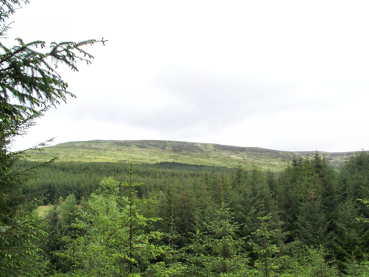
Peel Fell from the forestry track about half way up the border fence approach route |
Peel Fell lies in a moorland area sandwiched between the Kielder and Wauchope forests and most of the land in this area including the summit, on the English side of the border became "open country" following the implementation of CRoW in May 2005. There is however an area of land well down in the Keilder valley, near Lightpipe and Ravenshill through which one of the suggested routes passes, which is not in the "open country" area. On the Scottish side of the border the principles of responsible access apply, following the implementation in 2005 of the Land Reform (Scotland) Act 2003, which permits a far greater range of activities that the English CRoW legislation. For more details visit the Outdoor Access Scotland Website.
VHF activation from Peel Fell is possible with 5 watts and at least a half wave antenna although a beam will be more reliable. Take off is fairly clear into the Tyneside, Teesside and North & West Cumbria areas and into the Berwick to Hawick valley. Summit to summit with other SB summits but perhaps not Housedon Hill and SS, TW, NP, LD groups should be possible. NW and SP may also be possible, but most of the LD and NP summits lie in between.
|
|
|
 |
|
|
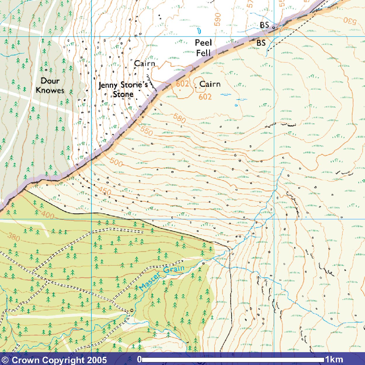
© Crown
Copyright 2005 Image produced from Ordnance Survey's Get-a-map service. Image reproduced with kind permission of Ordnance Survey and Ordnance Survey of Northern Ireland. |
|
Note that "open country" is indicated by the light yellow shading
Next SB Summit
Previous SB Summit
Getting There,
From the east take the A69 west and continue past the Hexham roundabout, but shortly after that roundabout take a right onto the A6079 (get into the right hand lane in plenty of time), through Acomb and Wall. When you reach the crossroads of the A6079 with the B6318 turn left onto the B6318 and cross the single track traffic light controlled bridge over the North Tyne river at Chollerford. At the roundabout on the other side of the bridge take the second exit straight up the hill on the other side signposted the B6320 to Bellingham. Continue on this road to Bellingham where you should watch for signs pointing left to the road to Kielder which you should take. Continue on this road past the Kielder reservoir and past Kielder village at the head of the reservoir. The forestry track to Deadwater fell is about 0.7 mile beyond Kielder village, the forestry track to the border fence about 1½miles further and the Scottish border is about 2.8 miles from Kielder village.
From the south take the A68 north off the A1M at junction 58 and continue north till the A68 merges onto the A69. Once on the A69 continue on it and follow the route as from the east.
From the south west take the M6 north to junction 44, where you should take the third exit from the roundabout, A7 north travelling toward Longtown. Continue on the A7 through Longtown and over the river Esk for about 5.3 miles beyond Longtown, when you will reach the village of Canonbie and the B6357 junction. Here you turn right into the B6357, and pass through the village bearing left at a T junction, then continue on the B6357, through Newcastleton. Keep on the B6357 until you come to a junction on your right signposted for Kielder. You will have travelled about 18 miles on the B6357 when you reach this junction. Turn right and south to follow the road to Kielder and you are now on the same route as from the north west
From the north west take A68 through Jedburgh and shortly after Jedburgh and just after a bridge over the Jed Water river you should see a roadsign pointing right to the B6357 to Bonchester Bridge which you should take. At Bonchester Bridge the B6357 merges temporarily with the A6088 and you should continue south along the B6357/A6088 continuing to follow the B6357 when it branches right from the A6088 toward Newcastleton. However long before reaching Newcastleton you will reach a junction where you turn left onto the road that is signposted for Kielder. The Scottish/English border signs indicate that the start of the border fence route to Peel Fell is just over half a mile further and the forestry road on the left which is the start of the Dead Water Fell route is about 2 miles south of the border.
From the north east take the A1 south
to the A69 on the Newcastle Western Bypass and then follow the route as
from the east
Suggested Approach,
There are several walking routes to the summit of Peel Fell, of which two
are described here. In fact these two routes are subsections of a popular
"Kielder Stane" circular route from Kielder Village.
 |
|
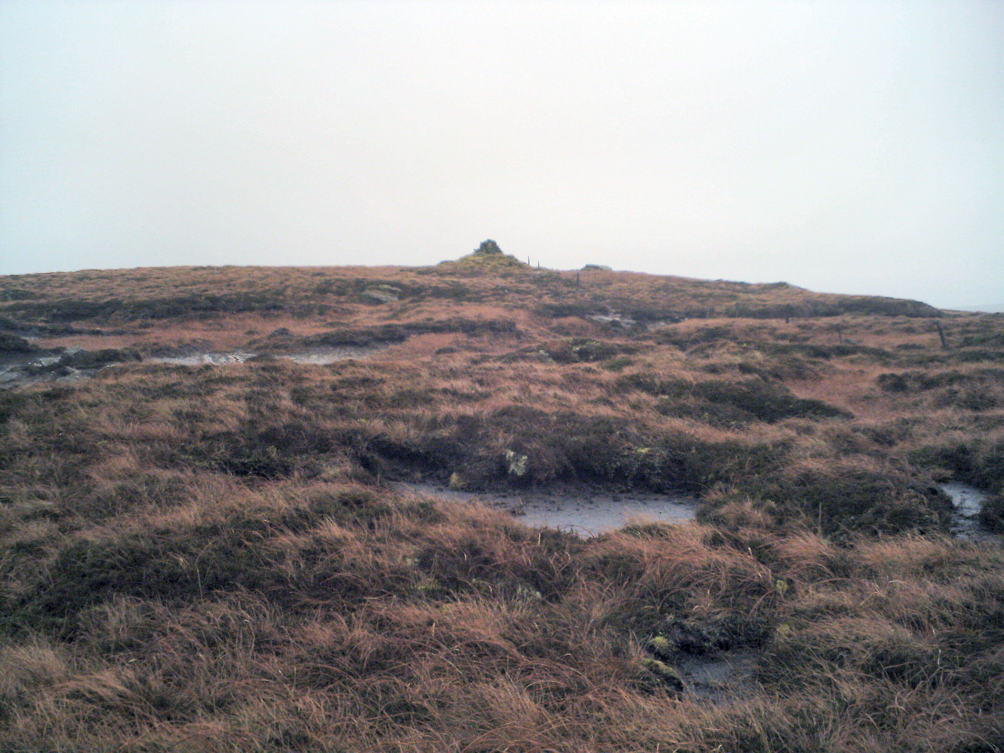
The cairn at the summit of Peel Fell. Note the number of small ponds. The top of Peel Fell is a bit of bog with many small ponds. |
The Deadwater Fell Approach:
approx walk in 4.75 miles 7.6km
Park at the start of the forestry/farm road at NY 62235 94550 or nearby
and then head north east up the road. This route is quite a popular route
with walkers. Either side of the road here is not "open country" within
CRoW. About 100 yards or so up the road at a Y junction take the left branch.
The right branch heads for Lightpipe. The forestry road should be fairly
easy to follow as it has been well used by vehicular traffic going to the
masts at the top of Deadwater Fell, so ignore other less obviously used
forestry roads. Key turning points are a right turn around NY 62185
95110, another right turn around NY 62115 95660
and a left turn at a Y junction at NY 61685 98195. Thereafter the
road is straight up to Dead Water Fell and its masts. As an
alternative to following the forest road it is possible to leave the
forest near NY 62700 95370 and follow the edge of the forest to rejoin
the forest road near NY 62840 95845. The moor here and from now on
upwards became "open country" from end May 2005. From Deadwater
Fell follow the track east north east that follows the ridge across Deadwater
Moor passing a small tarn on the left and heading toward Mid Fell with its
cairn. The ridge and its track swing in a sort of left handed semi-circle
towards Peel Fell at NY 62605 99710. Most of the ascent of this route
occurs on the forestry road leading up to Deadwater Fell and after that
the route follows the ridge with only marginal ascent/descent, so some
walkers prefer this approach.
The Border Fence Approach:
approx walk in 3.25 miles 5.25km
Park at or near the start of the forestry track at
 |
|
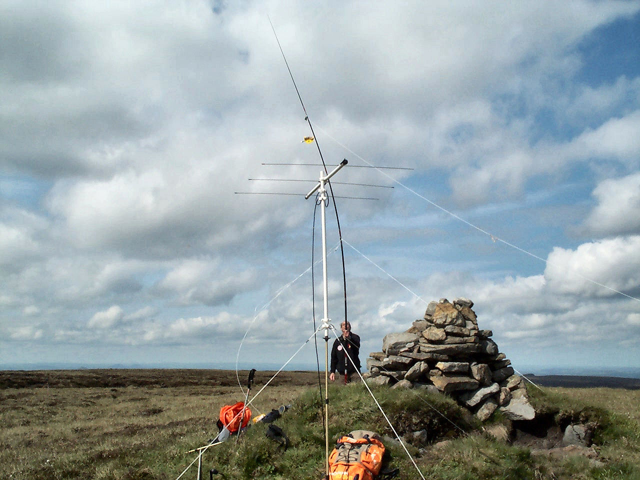
Dismantling the HF dipole. VHF beam in the foreground |
GPS Route Download,
Deadwater Fell Approach:
Download Garmin Mapsource
GDB format »
Download Memory Map format »
In using this route, if you decide to follow the edge of the forest, simply drop waypoints PFD07-PFD09 and connect PFD06 to PFD10. PFD10 is not exactly where the edge of the forest meets the road again but as the difference is about 60 yards, there shouldn't be a problem.
Border Fence Approach:
(updated 08/06/05)
Download Garmin Mapsource GDB
format »
Download Memory Map format »
Post Summit Retreat,
For refreshments after activation, between April and October the restaurants/bars
of the Kielder Castle, Leaplish Waterside Park. and Tower Knowe visitor
centres are open with hours varying, increasing around high season and reduced
at the beginning and end. Out of season or if something more in the line
of a pub is preferred, there is the Anglers Arms in Kielder village near
the castle or if you are returning down the Kielder valley, there
is the 300 year old Pheasant Inn with a reasonable selection of real ales,
at Stannersburn. Alternately continue on to Bellingham where there
are the Riverdale Hall Hotel, the Cheviot Hotel, the Rose & Crown pub, the
Fountain Cottage Tea Room and The Snack Bar café. Going out of Kielder in
the opposite direction into Scotland the choice is more limited. If heading
south west there is the Dormouse pub and the Copshaw Kitchen Restaurant
at Newcastleton but we currently have no information on these. If
heading north towards Jedburgh or Hawick, the Horse and Hound Country Inn
at Bonchester Bridge has a reputation for good food and drink. Alternately
continue on into either Hawick or Jedburgh in each of which there is selection
of pubs to choose from.
Last updated 9th June 2005