
Scottish Borders Region
Tosson Hill - G/SB-007
Next SB Summit
Previous SB Summit
| Grid Reference | NZ 00485 98243 |
| Latitude/Longitude | N55 16 42.1 W1 59 38.1 |
| Maidenhead Square | IO95AG |
| Height | 440 M / 1444 ft |
| Points | 1 |
| Bonus | None |
Summary,
Tosson Hill lies on a grouse moor adjacent to the Simonside forest and hills,
|
|
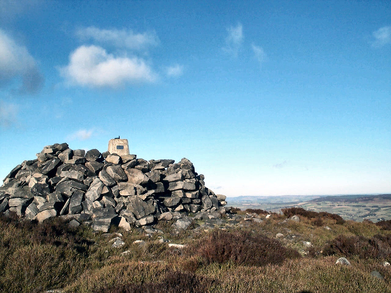
The Cheviot and Hedgehope can be seen in the distance beyond the trig point on Tosson summit |
As from implementation of CRoW at end May 2005 the moor land surrounding Tosson Hill became "open country" whereas it has been, depending on the season, an area carefully protected by its gamekeepers. Even with the advent of CRoW we can anticipate that the moor may be closed for access for the maximum permitted number of days, however these cannot be bank holidays and the number of Saturdays and/or Sundays that can be closed is limited. In practice it seems that so far the land owners are choosing to take much of their allowance of closed days from mid-May through mid-June, closing during weekdays but open at weekends and the intent seems to be to minimise disturbance of ground nesting birds. Details of closure are posted at entrance points to the access land and at some car parks (e.g. Lordenshaws) and these take the form of an A4 laminated sheet stapled to a post. Key however is the fact that the footpath across the Simonside ridge from Lordenshaws and the footpath beyond leading up to and across the Tosson ridge, including the Tosson summit, were formally established as public footpaths from 7th April, 2006 and as such these cannot be closed. Although this footpath is not currently waymarked, that is scheduled to take place in the Spring or early Summer of this year (2007)
With an early start this summit could be activated along with nearby Long Crag SB-008 in the same day. From this summit most of the other SB summits can be seen, The Cheviot very clear to the north north west, Long Crag clear in the north north east, and Ros Hill stands out as a pimple on the northern horizon just to the left of Long Crag. Although more difficult to identify Shillhope Law is line of sight slightly north of east and to the left of The Cheviot. Peel Feel is somewhat obscured by the ridge of Wool Meath but is line of sight rising up from the Kielder Forest that can be seen stretched out to the east. A little further round to the west south west, Sighty Crag also rises up from the Kielder Forest. Housedon Hill is indeed the only SB summit that is not within line of sight of Tosson Hill as it lies almost directly behind Hedgehope.
This summit should be fairly readily activated on VHF, as it has an excellent take off into Tyneside, the Tyne Valley, much of Northumberland and has a clear path into the Irthing/North Eden valley. It may be possible to work from this summit with a rubber duck, although something more substantial is recommended, and more likely to result in a qualified activation if operating early in the day. Summit to summit contacts should be possible with other SB summits, TW, NP and LD regions, and any south western GM/SS that may be activated.
|
|
|
 |
|
|
© Crown
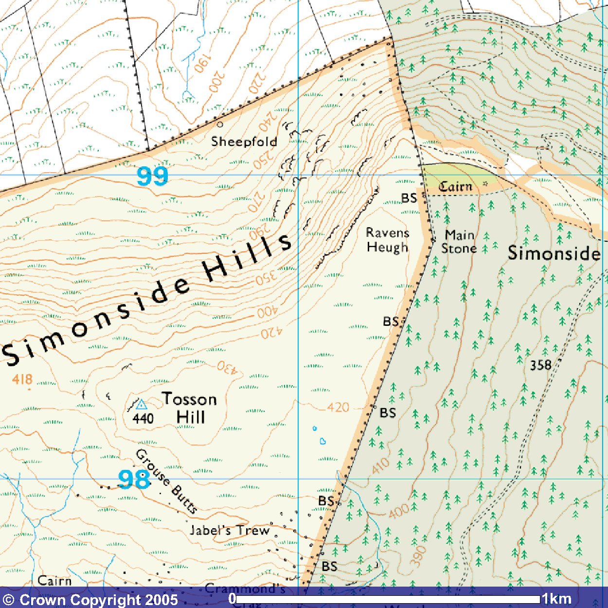
Copyright 2005 Image produced from Ordnance Survey's Get-a-map service. Image reproduced with kind permission of Ordnance Survey and Ordnance Survey of Northern Ireland. |
|
Note that "open country" is indicated by the light yellow shading
Next SB Summit
Previous SB Summit
Getting There,
From the south there are two main options:
- Take the A697 north off the A1 just north of Morpeth, passing through
the Northumberland village of Longhorsley. About 2½ miles north of Longhorsley
after quite a long downhill run, in the dip before a long steady rise
toward the village of Longframlington, take the B6344 left for Rothbury.
Shortly after entering Rothbury take a left onto the B6342 and cross
the river Coquet but at the end of the bridge where the B6342 turns
left, take the opposite direction and turn right into a minor road.
Continue on this road for about 0.4 of a mile from the bridge to a T
junction where you take the road to the the right signposted for Great
Tosson . After another 1½ miles there is a road on the left signposted
for Great Tosson and Lordenshaws and when you reach the farmstead at
Great Tosson after another 0.4 mile, you take a very sharp left turn
which leads up to Simonside. About 0.7 mile from Great Tosson, the turn
into the forest car park is on your right NZ 03695 99704.
- From the A1 Newcastle Western Bypass take the slip road signposted for the A696 to Jedburgh and Ponteland, and proceed along this dual carriageway past Newcastle Airport, through Ponteland and the village of Belsay. About 4¼ miles beyond Belsay there is on the right a single track road signposted for Deanham which you can take. Alternately you can proceed a further mile on the A696 and then turn sharp right onto the B6342 signposted for Rothbury. These two roads roads converge just before Wallington, and you should continue to follow the B6342, through Cambo and on towards Rothbury taking particular care over the hump back bridges on this road. About 2½ miles before Rothbury, where the B6342 road has a right turn, a single track road goes straight on across a cattle grid. Continue along this single track road until you see the signs for the Simonside forest car park.
From the north west take the A697 south off the A68 at Carfraemill passing through Coldstream, Wooler, and Powburn. 7 miles south of Powburn there is a crossroads of the A697 with the B6341 which is signposted to the right for Rothbury and you should turn into this road. This will bring you into Rothbury and from here follow the first option directions as from the south above.
From the north east take the A1 south to
Alnwick and just after the road opens to a dual carriageway, take the slip
road up the ramp and turn right across the bridge toward Alnwick.
You have to follow signs toward the centre of Alnwick but keep an eye out
for signs for the B6341 to Rothbury and take that road. Just over
6½ miles from the outskirts of Alnwick there is a crossroads of the B6341
with the A697. Continue straight across this which will take you into Rothbury
and from here follow the first option directions as from the south above.
Suggested Approach,
approx. walk in 2.9 miles 4.66km
There is a network of parking areas NZ 03695 99704 interspersed among the
trees, which can be quite densely occupied at peak leisure times. From the
car park follow the
|
|
|
A hollow cairn surrounds the trig point on Tosson summit. This trig point bears a plate indicating that it is an OS Passive Station used as a GPS reference point |
When you reach the forest road just below the Simonside summit continue to follow the orange route along the side of the taller trees but where the orange route breaks away from the trees, ignore that and follow the track that continues upward along the edge of the trees. This will lead up to a fence with a sort of wooden gate and the remnants of a sign that used to indicate private land NZ 01403 99025. Across the fence is an obvious track that leads across the moor but while you can approach the summit on this track it will take you below the north facing crags and along the side of a rather steep slope, with the track becoming very indistinct and difficult to follow. Instead of following that, after crossing the fence turn left and follow the fence for about 20-30 yards (count 12 fence posts) where you should see a large (2½ft) boulder on the ground NZ 01413 98980. At this point, you will see a cairn out in the moorland NZ 01274 98859 and if you head across the lower area of heather that is here, you should pick up a track going across to that cairn. Do not be misled by areas of heather that have been cut by a new kind of heather cutting machine as these generally lead no where or go round in circles. From that cairn a fairly obvious track crosses the moorland to the summit of Tosson hill. This track across Tosson ridge together with the track up from the forestry orange route, was established as a new public right of way from 7th April 2006. This summit like most in the region is very rounded providing a fairly large potential activation area. The trigpoint is surrounded by a low dry stone wall almost like a hollow cairn, probably constructed by walkers but choosing a position around this will provide some shelter from the wind.
There is another route into this summit from the west near Hepple Whitefield of about 2.6 miles 4.1 km but this is currently not recommended. In the spring of 2006 the path across the Tosson ridge from the bridleway between Hepple Whitefield and Chartners to the track that can be seen in the map above, as a solid line just above the word Cairn near Ravens Heugh towards the top right corner, became a public footpath. If you want to try this approach then park on a triangle of grass at NY 9872 9964 and follow the bridleway towards Chartners. When you arrive at NY 98608 97512 you should see a low level post with a bridleway disk on it and to your left is a short track leading down to some storage sheds. From this point the new public footpath goes in almost a straight line across the moorland to the summit of Tosson except that there is no evidence of any track and you are simply trudging across heather. Occasionally you may think you have found the track but more likely it will be a sheep track that will just fade out.
This new public footpath is clear over the Simonside ridge and across the Tosson ridge up to the Tosson summit but to the south west beyond that, no obvious path can be found. We anticipate that once waymarking of the public footpath is completed in the first half of 2007, a path will develop as people begin to walk it.
GPS Route Download,
Download Garmin Mapsource GDB
format »
Download Memory Map format »
Post Summit Retreat,
For refreshments after activation, as with Long Crag, the Newcastle Hotel
in Rothbury 4 miles 6.4km north east of Tosson Hill or about 3 miles 4.8km
by road from the Simonside forest car park, is recommended and provides
a good watering hole. Good quality food is generally available over a considerable
part of the day at weekends and a selection of reasonable hand pumped ales
is usually on tap. Although the hotel changed hands in 2006 our
experience of eating there in the Spring of 2007 was good. At busy times of day it is best to park in a fairly large
car park on the south side of the river Coquet at NU 05715 01515 which you
will arrive at just as you arrive in Rothbury if returning from the summit
and then cross the river over a foot bridge. As you come up to the main
street, the Newcastle Hotel is on your right. Just to the right of
the hotel as you face it is the Northumberland National Park Information
Centre where useful information about the broader area can be obtained.
Last updated 13th April, 2007. Please report any issues or errors, even spelling!!