
Scottish Borders Region
Long Crag - G/SB-008
Next SB Summit
Previous SB Summit
| Grid Reference | NU 06223 06933 |
| Latitude/Longitude | 55°21'23.0"N, 1°54'12.2"W |
| Maidenhead Square | IO95BI |
| Height | 319 M / 1047 ft |
| Points | 1 |
| Bonus | None |
Summary,
Long Crag is located in mid Northumberland just a few miles north of the villages of
|
|
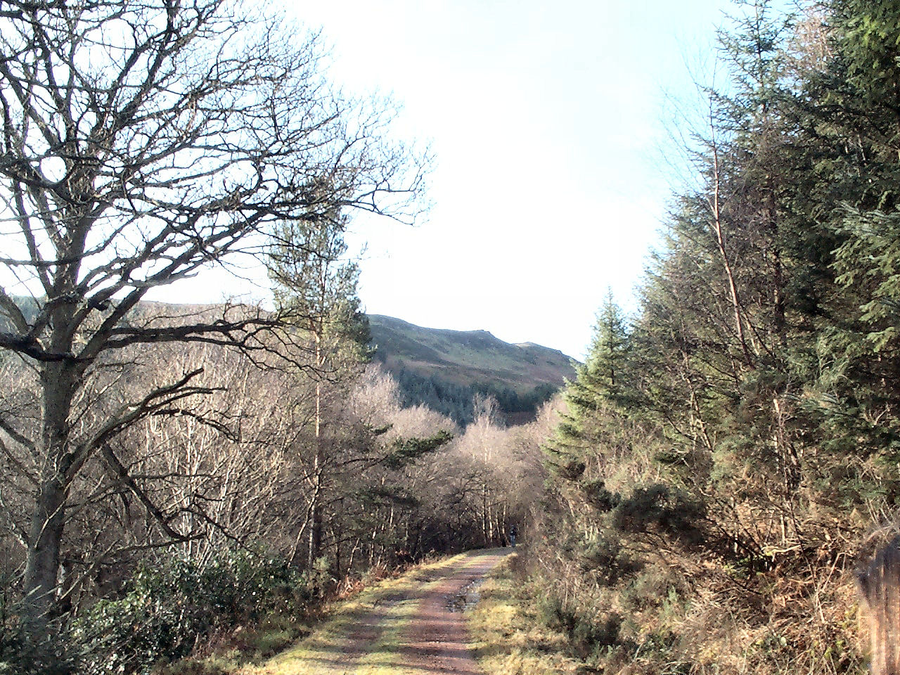
Long Crag from the forestry road on the Red Route that leads to the track up the hill. |
The whole of the suggested route to this summit once it clears the trees and all the surrounding land along the ridge is "open country" following the implementation of CRoW at end May 2005.
From this summit several other summits of the SB group can be clearly seen, Ros Hill to the north, The Cheviot to the north west, and Tosson Hill to the south west. This summit is about 6½ miles as the crow flies from Tosson Hill G/SB-007 and with an early start, both can be activated in one day.
VHF activation of this summit should present no problems with a strong signal into the Tyneside and Tyne Valley areas and most of Northumberland. Although a rubber duck is likely to work, to ensure a successful qualification something around a half wave would be advisable and will obtain 59+ reports from Tyneside. Summit to summit QSOs should be possible with other SB summits, TW, NP and LD regions and the south western GM/SS summits.
|
|
|
 |
|
|
© Crown
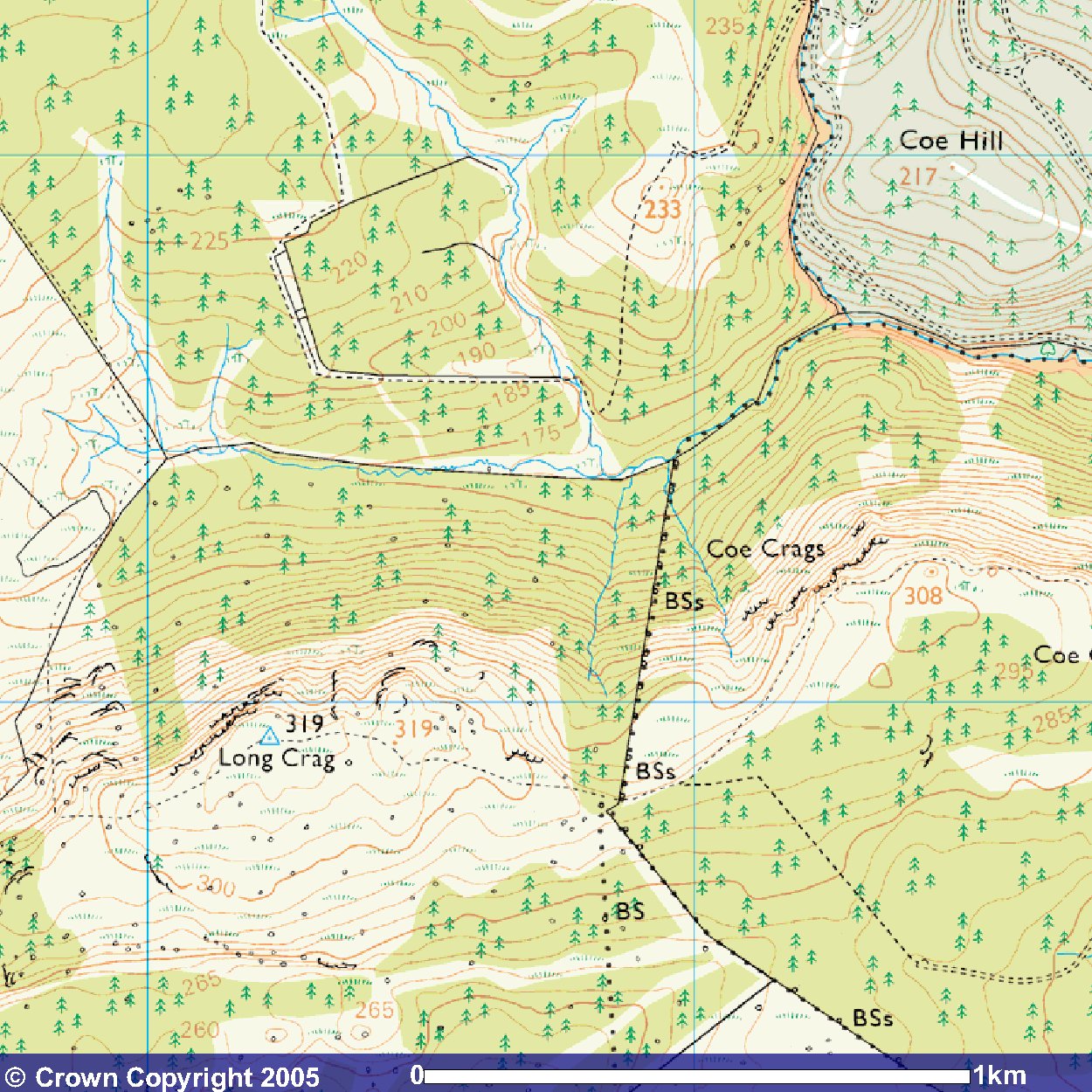
Copyright 2005 Image produced from Ordnance Survey's Get-a-map service. Image reproduced with kind permission of Ordnance Survey and Ordnance Survey of Northern Ireland. |
|
Note that "open country" is indicated by the light yellow shading
Next SB Summit
Previous SB Summit
Getting There,
From the south take the A697 north off the A1 just north of Morpeth, passing through the Northumberland villages of Longhorsley and Longframlington. Just over 4 miles north of Longframlington, shortly after the B6341 Alnwick - Rothbury cross road, a single track road road signposted for Thrunton Wood branches off to the left. For the Beehive approach stop by or opposite the gate across a forestry road on your right a short distance along this road at NU 09169 07215. For the Red Route, continue down into the dip and at NU 08695 08760 there is a forestry road on the left where there is sufficient space for four or five cars before the locked gate and there is some further parking possible on the grass verge just beyond the forestry road. The main car park for Thrunton woods is by the trees about half a mile further up the single track road and at busy times it may be necessary to park there and walk back down the hill.
From the north west take the A697 south off the A68 at Carfraemill passing through Coldstream, Wooler and Powburn. 6½ miles south of Powburn a single track road on the right requiring a turn of almost 340° is signposted and leads to Thrunton Woods. As you approach the turn a mast cluttered with mobile phone and other antennae is very obvious on the right side of the road and the turn is almost immediately after that. It is actually possible to turn into Thrunton woods off the A697 earlier but unless heading for the main car park there is probably not much advantage, because of the nature of the road.
From the north east take the A1 south to
Alnwick and just after the road opens to a dual carriageway, take the slip
road up the ramp and turn right across the bridge toward Alnwick.
You have to follow signs toward the centre of Alnwick but keep an eye out
for signs for the B6341 to Rothbury and take that road. Just over
6½ miles from the outskirts of Alnwick there is a crossroads of the B6341
with the A697. At this junction turn right (north) and the single track
road into Thrunton Woods as for from the south is just half a mile to the
north.
Suggested Approach,
There are several possible walking routes to ascend Long Crag of which
two are described in detail here and a third route will be
explored at some time in the future.
The Beehive Approach: approx. walk 2.1 miles 3.4km
There is space for a few cars either side of the road at NU 09169 07215 where there is a very small lay-by
|
|
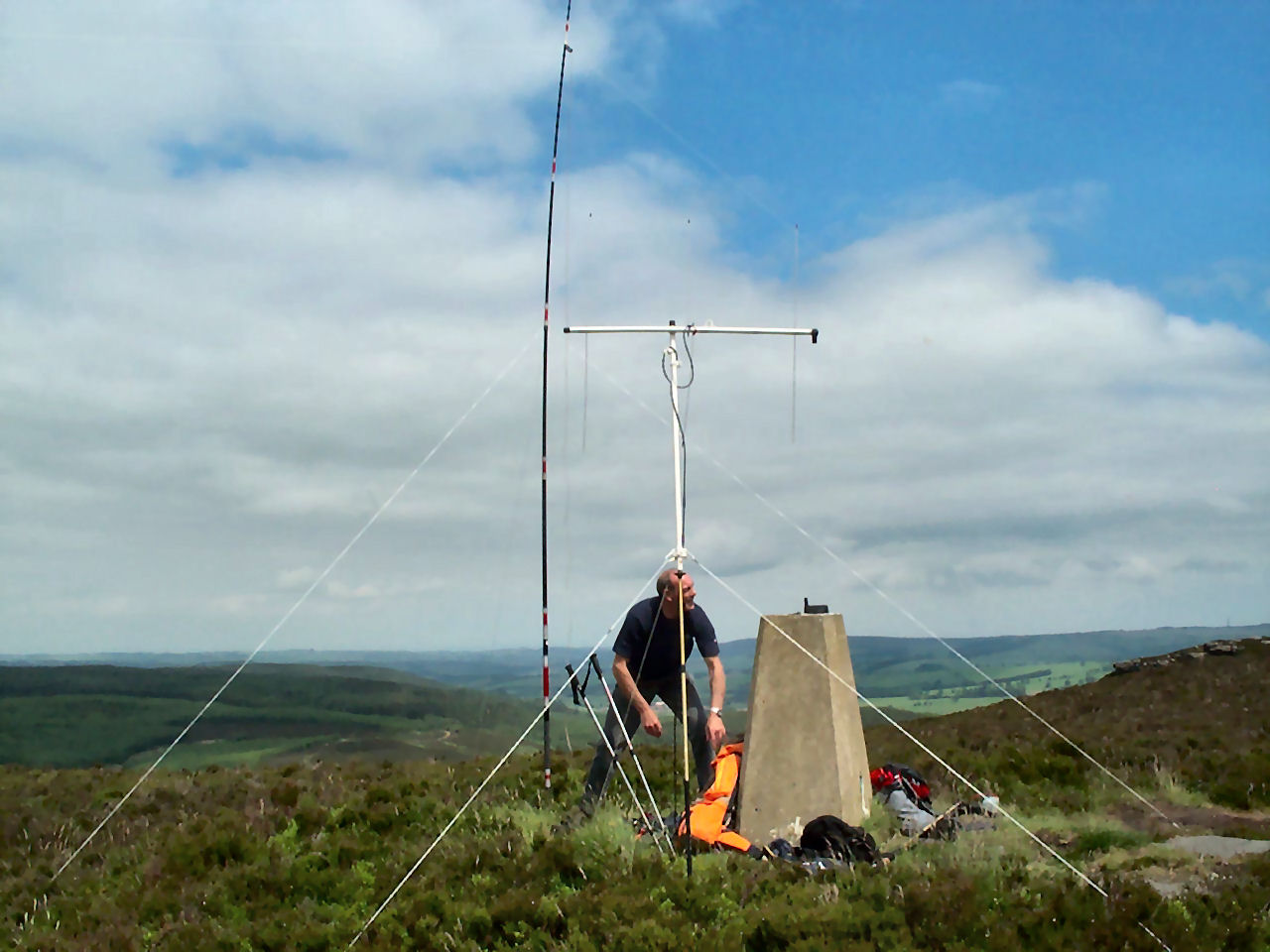
The SOTA Beam mounted on the WASP aiming south from Long Crag with the SOTA pole supporting the HF dipole just behind. The GPS is sitting on the trig point. |
At NU 07320 06640, where the well used track turns to the left, you will see straight ahead the original path that is marked on the OS map where there is a sign advising of the presence of beehives, hence the name we gave this route. Follow the well used route to the left and continue for about 300 yards to NU 07006 06612 where the track divides and you take the right branch up a moderately steep track. After another 300 yards you reach another junction where you take the left branch and you are now on the same track as the Red Route described below. Continue for about 700 yards on this track until you come to the trig point slightly offset to the right of the main path. On the way you will pass an unmarked secondary summit or your right that is also mapped at 319 metres and is within the activation zone.
Beyond the trig point you will see another cairn a short distance away - why this is there we have not been able to determine but it is within the activation zone. Indeed there is quite a large activation zone surrounding the trig point so the are several options for an operating site although because of the vegetation it is easier to set up near the trig point.
The Red Route: approx. walk 2.8 miles 4.5km
This approach forms part of the forestry "red route walk" but in the
reverse direction.
There is space for just a few cars to park at the edge of the forestry track
or on the grass verges at NU 08703 08738 otherwise you will have to
proceed half a mile further along the road to a fairly large car park at
NU 08485 09265 and walk back to this forestry road. Follow the forestry
road keeping to the left at any intersection although it should be obvious
as any other forestry road branching off is grass covered.
|
|
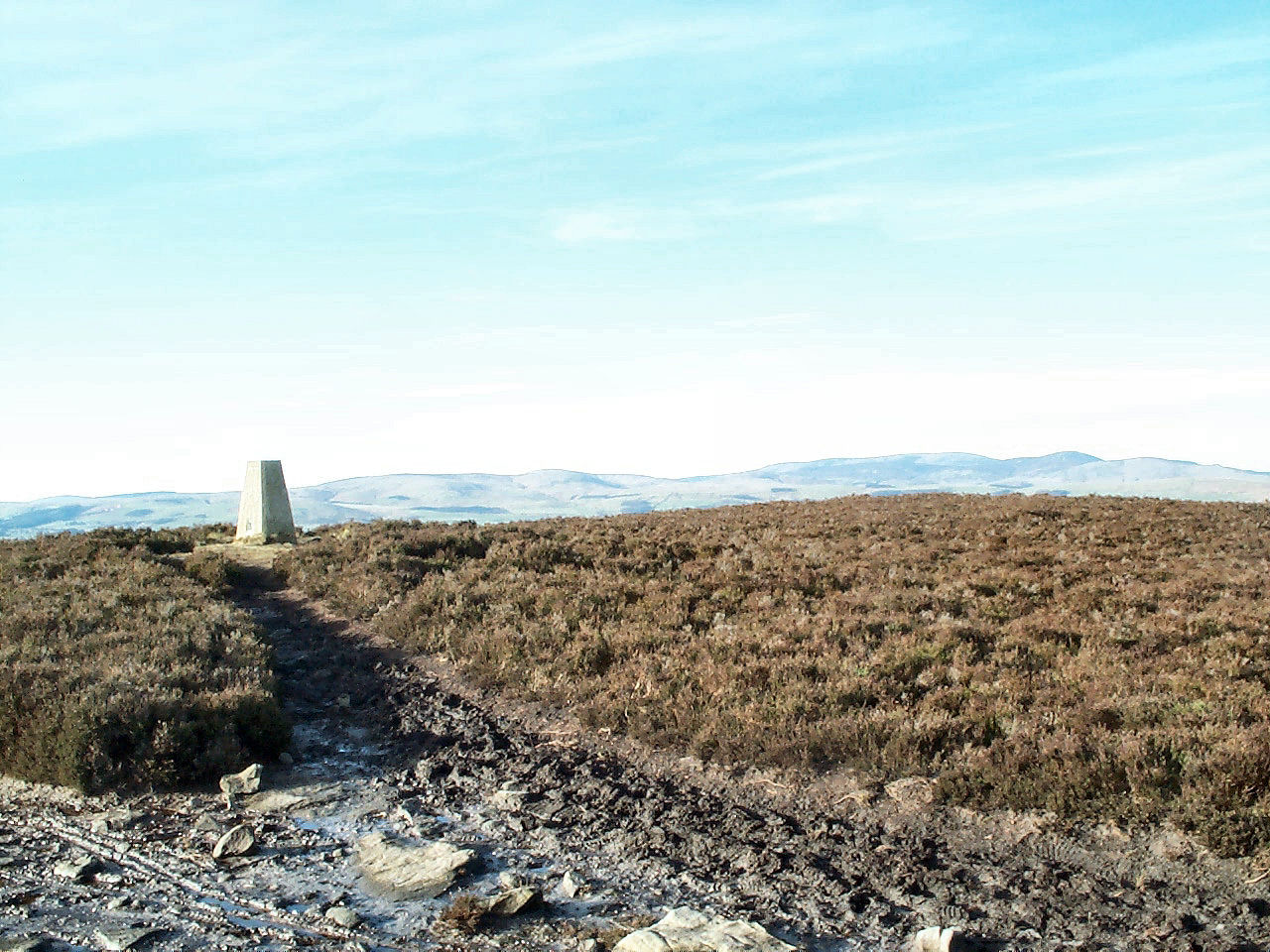
The Cheviot hills with The Cheviot and Hedgehope to the far right of the picture can be seen behind the trig point of Long Crag summit |
If you prefer not to try this crossing then continue on the forestry road for another 350 yards to around NU 07917 07592 where the main track goes off to the left from the forestry road and leads to a footbridge across the stream. From now on it is just a matter of continuing to follow the track up the hill. The first cairn that you reach at Coe Crags NU 07428 07242, may make you think this is the summit but this is a minor summit at 308 meters and not within the activation zone since the col between this point and the Long Crag summit drops to 290 metres, so you should continue on the path for another 0.8 mile to where the trig point is located at NU 06223 06932 just a few yards from the path.
There is another possible route into this summit from the west near Lorbottle Hall, of about 2.4 miles but this remains to be reconnoitred and will be added to this page if appropriate at a later date.
GPS Route Download,
Beehive Approach: (updated 26/06/05)
Download Garmin Mapsource GDB
format »
Download Memory Map format »
The Red Route: (updated 26/06/05)
Download Garmin Mapsource GDB
format »
Download Memory Map format »
In using these "Red Route" routes, if you decide to take the shortcut described, simply drop waypoints LCF11-LCF16 and connect LCF10 to LCF17. This will not provide a route that exactly follows the shortcut but given the nature and clarity of the track shouldn't present any issues.
Post Summit Retreat,
For refreshments after activation, the Newcastle Hotel in Rothbury, also
recommended for SB-007Tosson Hill, 3½ miles south of Long Crag provides
is a good watering hole. Good quality food is generally available over a
considerable part of the day especially at weekends and a selection of reasonable hand
pumped ales is usually on tap. At busy times of day it is best to park in
a fairly large car park on the south side of the river Coquet at NU 05715
01515 and then cross the river over a foot bridge. As you come up to the
main street from that car park, the Newcastle Hotel is on your right.
Just to the right of the hotel as you face it is the Northumberland National
Park Information Centre where useful information about the broader area
can be obtained.
Last updated 26th June 2005